Navigating the 2026 El Niño: Turning Forecasts into Early Action in the Horn of Africa - ENA English


Navigating the 2026 El Niño: Turning Forecasts into Early Action in the Horn of Africa
By Gizachew Meku
The Horn of Africa is approaching the final months of 2026 with an increasingly important climate signal that is a strengthening El Niño that could bring substantially wetter conditions to parts of the region while increasing the risks of flooding, landslides, crop damage, disease outbreaks and infrastructure disruption.
El Niño is a recurring climate phenomenon in which unusually warm sea-surface temperatures in the central and eastern tropical Pacific alter atmospheric circulation, affecting rainfall and temperatures far beyond the Pacific. Its impacts vary by region and season, making it an important factor in seasonal forecasting and preparedness.
For the Horn, the latest forecasts show that the region faces neither a uniformly wet nor uniformly hazardous season. Rather, the impacts are likely to vary significantly by location, timing and intensity of rainfall. This makes the ability to translate forecasts into timely, localized decisions more important than simply predicting whether the coming season will be wet or dry.
The World Meteorological Organization (WMO) reported in September that El Niño is firmly established and expected to strengthen to a very strong event toward the end of 2026. WMO forecasts indicate an exceptionally high likelihood, nearly 100 percent, that the phenomenon will persist through February 2027. The organization has also warned that the combination of El Niño and other oceanic conditions could produce significant changes in rainfall and temperature patterns, increasing the risk of extreme weather in different parts of the world.
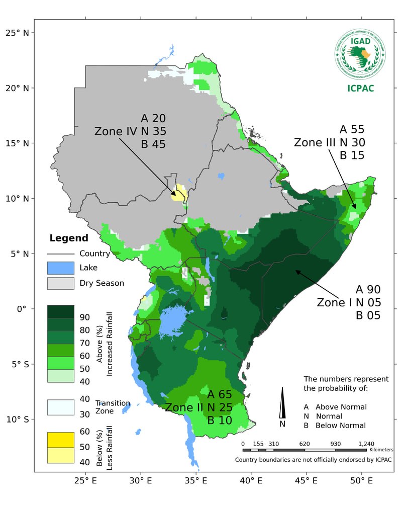
For the Greater Horn of Africa, the latest regional outlook provides a more specific picture. The IGAD Climate Prediction and Applications Centre (ICPAC) forecasts a 90 percent likelihood of enhanced October to December rainfall over southern Ethiopia, central and southern Somalia and northeastern Kenya. It also identifies a high likelihood of seasonal rainfall exceeding 400 millimeters in parts of central and southern Somalia, central Kenya, the Lake Victoria Basin, Burundi, western Rwanda and western Tanzania.
The October to December season is particularly important for several countries in the region. ICPAC notes that it can account for up to 70 percent of annual rainfall in parts of Ethiopia, Kenya and Somalia and up to 40 percent in parts of Rwanda, Burundi, Tanzania and Uganda. Consequently, the quality and distribution of these rains can have major implications for agriculture, livestock, water availability and food security.
The Dual Nature of the Forecast
The forecast presents both opportunities and risks. For communities affected by water shortages and poor pasture conditions, increased rainfall could replenish rivers, reservoirs and groundwater, regenerate grazing areas and improve crop and livestock production. In agricultural areas, timely and well distributed rainfall could support planting and crop development while improving household and market food supplies.
However, rainfall that arrives too intensely or over a short period can produce the opposite result. Heavy downpours can overwhelm drainage systems, cause flash floods and landslides, erode farmland, damage crops and disrupt roads, bridges, schools, health facilities and markets. Flooding can also contaminate water sources and increase the risk of waterborne diseases.
ICPAC's latest outlook therefore emphasizes that seasonal forecasts must not be interpreted as a guarantee of rainfall at a particular location or on a particular day. The centre recommends using the seasonal outlook together with weekly and monthly forecasts, climate monitoring information and forecasts issued by national meteorological and hydrological services.
Temperature presents another dimension of the risk. ICPAC expects warmer than average conditions across much of the Greater Horn, while WMO's global outlook also points to widespread above normal temperatures during the September to November period.
The combination of heat and heavy rainfall can create complex pressures. High temperatures can increase water demand and stress livestock, while intense rainfall can produce flooding and disease risks. In other words, a wetter season does not automatically eliminate the effects of drought or climate vulnerability.
Ethiopia illustrates this complexity. Southern parts of the country are among the areas where enhanced October to December rainfall is anticipated. Such rains could support agricultural and livestock activities, particularly where communities have experienced water and pasture pressures. At the same time, intense rainfall could produce localized flooding, waterlogging, soil erosion and damage to roads and other infrastructure.
The same combination of opportunity and risk extends across Somalia, Kenya, Uganda, Rwanda, Burundi and Tanzania. The precise consequences will depend on where rainfall occurs, when it arrives and how rapidly it accumulates.
The central question, therefore, is not simply what El Niño will bring. It is whether governments, humanitarian agencies, farmers, pastoralists and communities can act on the available information before forecast risks become humanitarian and economic emergencies.
From Forecasts to Decisions
The existence of a forecast creates a valuable window for early action. Agricultural authorities can use climate information to adjust planting recommendations, promote appropriate crop varieties and provide farmers with advice on soil and water management. Where flooding is expected, authorities can strengthen drainage systems and identify areas where planting decisions need to account for excessive moisture.
Livestock authorities can support pastoralists with information on pasture and water availability, strengthen animal health surveillance, prepare vaccination campaigns and facilitate access to fodder where necessary.
Water authorities can monitor reservoirs, rivers and flood prone areas while preparing water management measures in advance. Urban administrations can inspect drainage systems, clear blocked waterways and identify communities and infrastructure exposed to flooding.
Infrastructure authorities can assess vulnerable roads, bridges, culverts and water facilities before heavy rains arrive. Where possible, preventive maintenance can be undertaken before access becomes difficult.
Health authorities also have an important role. Flooding and standing water can increase the risk of diseases such as cholera and malaria in vulnerable areas. Strengthening surveillance, preparing health facilities and prepositioning medicines and other supplies can allow health systems to respond more rapidly when cases begin to rise.
Social protection systems can similarly prepare mechanisms for supporting households whose livelihoods may be affected. Early assistance can help vulnerable families avoid selling livestock, tools, seed stocks or other productive assets to meet immediate food and household needs.
These measures are at the heart of anticipatory action: identifying a foreseeable hazard, establishing agreed thresholds and taking predefined measures before the impact becomes severe.
Regional Preparedness Is Underway
The need to move from forecasting to implementation has already been recognized at regional level. The IGAD High Level Forum on El Niño Preparedness, held in Addis Ababa from September 15 to 17, focused on preparedness, anticipatory action and resilience. The resulting IGAD High Level Call to Action calls for national and local contingency plans to be updated and activated, with clear arrangements for evacuation and humanitarian access.
The regional call also emphasizes the prepositioning of food, health, water, sanitation and hygiene supplies, protection of critical infrastructure such as roads, bridges and health facilities, and strengthened surveillance of flood related diseases including cholera and malaria. It further calls for timely agricultural advisories, livestock vaccination and measures to protect pastoral livelihoods.
The significance of these measures lies in timing. Food assistance that arrives after roads have been cut off by floods is less effective than supplies positioned before access is disrupted. Veterinary support delivered after livestock disease has spread is more difficult than preventive vaccination and surveillance. Emergency shelter provided after communities have been displaced is more costly and logistically difficult than preparing evacuation sites and access routes beforehand.
This is why the next stage of regional preparedness should focus on implementation at community level. Forecast information needs to reach farmers, pastoralists, local administrators, health workers and communities in forms they can understand and use. A seasonal probability expressed in technical language has limited value unless it is translated into practical advice such as when to plant, where to move livestock, which areas to avoid and when to prepare for possible evacuation.
Financing Early Action
Financing remains one of the most important conditions for successful anticipatory action. In June 2026, the Food and Agriculture Organization (FAO) and the World Food Programme (WFP) launched a joint El Niño anticipatory action appeal seeking USD 202 million to protect 8.8 million people across 22 high risk countries. The proposed measures include cash assistance, climate resilient seeds, livestock protection, water harvesting and storage, flood protection, agricultural advisories and early warning information.
The appeal reflects a broader shift in humanitarian policy from responding after disasters occur to acting before predictable shocks cause major losses.
The economic argument for this approach is also significant. WFP reports that experience from previous El Niño events indicates that every dollar invested in anticipatory action can save between USD 3 and USD 7 in avoided losses and response costs. FAO has similarly reported that anticipatory action can generate up to USD 7 in benefits and avoided agricultural losses for every dollar invested.
These figures do not mean that every intervention will produce the same financial return. Outcomes depend on the hazard, location, intervention, timing and population affected. They nevertheless demonstrate why investing before a predictable climate shock can be economically more efficient than relying exclusively on emergency response after losses have occurred.For the Horn of Africa, financing mechanisms need to be sufficiently flexible to release resources when agreed forecast thresholds are reached. Waiting for visible disaster impacts before mobilizing funds can undermine the very purpose of anticipatory action.
The Importance of Local Forecasts
One of the most important lessons from the current outlook is that a regional forecast cannot substitute for local information. ICPAC's seasonal forecast provides a broad picture of expected climate conditions across the Greater Horn. National meteorological and hydrological services provide increasingly detailed information that can guide decisions at national and local levels. Weekly and monthly updates can then help authorities determine whether anticipated conditions are materializing and whether planned interventions should be activated or adjusted.
This layered approach is particularly important because rainfall can vary substantially over relatively short distances. Two communities in the same district may experience different rainfall amounts and different levels of flood exposure.
For that reason, preparedness plans should include clearly defined trigger points. These could relate to rainfall totals, river levels, soil moisture, reservoir conditions, flood forecasts, disease indicators or other locally relevant thresholds. Once a threshold is reached, the corresponding action should already be agreed. This could mean releasing cash assistance, moving livestock, distributing seeds, reinforcing flood protection, opening temporary shelters or deploying health teams. Such systems reduce the gap between receiving information and making decisions.
Agriculture and Livelihoods at the Center
Agriculture and livestock deserve particular attention because climate shocks can produce consequences that extend well beyond a single season. A flood can destroy standing crops, wash away topsoil, damage irrigation systems and interrupt access to markets. For pastoralists, excessive rainfall can improve pasture in some areas while simultaneously increasing animal disease risks or making movement difficult.
The impact on households can therefore depend not only on the amount of rainfall but also on their ability to absorb and recover from shocks. Early action can help protect this productive capacity. Climate informed planting advice, flood tolerant or short cycle seeds, livestock vaccination, fodder support and water management can reduce losses while helping households maintain their livelihoods.
This is particularly important in areas where communities have already experienced repeated drought, conflict, displacement or economic pressures. A new climate shock can compound existing vulnerabilities, making early intervention more valuable.
Health Risks Require Early Attention
Flood preparedness should also be treated as a public health priority. Flooding can contaminate drinking water and sanitation systems, increase exposure to waterborne diseases and create breeding conditions for disease vectors. At the same time, disruption of roads and health facilities can make it more difficult for communities to obtain treatment.
The IGAD High Level Call to Action specifically highlights strengthened health surveillance for flood related diseases such as cholera and malaria. Early warning systems can therefore serve more than disaster management agencies. Information about expected rainfall and flooding can allow health authorities to increase surveillance, prepare medical supplies, strengthen community awareness and coordinate with water and sanitation agencies before outbreaks escalate.
The Cost of Waiting
The consequences of delayed action can extend for years. Flood damaged roads and bridges require expensive reconstruction. Crop losses can reduce household income and food availability. Livestock losses can remove a major source of wealth and livelihood for pastoral families. Damage to water systems can create prolonged public health problems, while repeated shocks can push vulnerable households deeper into poverty.
The experience of previous El Niño events demonstrates the scale of these risks. WFP has noted that the 2015 to 2016 El Niño affected the food security of an estimated 60 million to 100 million people globally. For the 2026 to 2027 event, WFP has warned that climate impacts could add substantially to existing food insecurity in countries already facing conflict, displacement and economic pressures. The figures underline an important point: climate forecasting is not an end in itself. Its value is measured by whether information changes decisions early enough to reduce harm.
A Narrow Window for Action
The Horn of Africa enters the October to December season with an unusual combination of information and uncertainty. The regional climate signal is sufficiently strong to justify preparedness. At the same time, forecasts cannot determine every local outcome months in advance. The timing and intensity of rainfall can change, and conditions can differ considerably between neighboring areas.
That uncertainty should encourage flexibility rather than delay. Governments and partners can establish contingency plans based on several possible scenarios, prepare resources in advance and update decisions as new forecasts become available. Communities can be given clear information about what actions to take under different rainfall and flood scenarios. The objective should not be to predict every event perfectly. It should be to reduce the consequences of foreseeable risks.
Conclusion
The Horn of Africa has three important assets as it approaches the final months of 2026: increasingly clear regional climate information, established early warning systems and growing experience with anticipatory action.
The latest ICPAC outlook points to a high likelihood of enhanced rainfall across parts of the southern and equatorial Greater Horn, while WMO expects El Niño to strengthen and persist into early 2027. At the same time, the regional outlook warns of warmer than average temperatures and the possibility of flooding and other climate related hazards.
The challenge now is to close the gap between forecast and action. Farmers need timely and usable information. Pastoralists need livestock and water preparedness. Health authorities need surveillance and supplies. Infrastructure agencies need to protect vulnerable assets. Humanitarian organizations need resources before emergencies peak. Most importantly, communities need to be placed at the center of preparedness decisions.
El Niño carries uncertainty, but uncertainty does not mean that nothing can be done. Forecasts can identify elevated risks, early warning systems can establish triggers, financing can support timely interventions and local institutions can translate regional information into practical action.
For the Horn of Africa, the measure of preparedness will ultimately be whether the region uses the warning it has today to reduce the losses it might otherwise face tomorrow.


